莫米河
外觀
| Maumee River 莫米河 | |
|---|---|
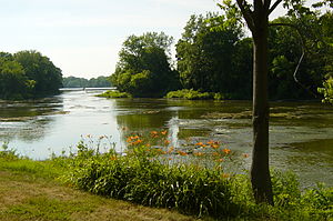
 流經俄亥俄州大急流城的莫米河 | |
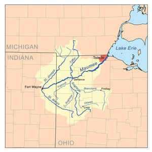
 莫米河流域圖 | |
| 國家 | |
| 州 | |
| 城市與城鎮 | 韋恩堡; 紐黑文; Antwerp, Ohio; Cecil, Ohio; 迪法恩斯; Florida, Ohio; 拿破崙; Grand Rapids, Ohio; Waterville, Ohio; Maumee, Ohio; Perrysburg, Ohio; Rossford, Ohio; 托萊多; Oregon, Ohio |
| 流域 | |
| 流向 | 東北 |
| 源頭 | |
| • 位置 | 韋恩堡,St. Joseph與St. Marys匯合 |
| • 座標 | 41°04′58″N 85°07′56″W / 41.0827778°N 85.1322222°W |
| • 海拔 | 750英尺(230米) |
| 河口 | |
| • 位置 | 伊利湖,俄亥俄州托萊多 |
| • 座標 | 41°41′58″N 83°27′36″W / 41.6994444°N 83.46°W |
| • 海拔 | 571英尺(174米) |
| 流域面積 | 6,354 sq mi(16,460 km2) |
| 本貌 | |
| 長度 | 137英里(220公里) |
| 流量 | |
| • 平均流量 | 5,297 cu ft/s(150.0 m3/s) |
莫米河(英語:Maumee River[1]肖尼語:Hotaawathiipi;[2][3])是美國印第安納州東北部與俄亥俄州西北部的一條河流,注入伊利湖。
參考文獻
[編輯]- ^ Maumee – Definition and More from the Free Merriam-Webster Dictionary. Merriam-webster.com. [November 1, 2012]. (原始內容存檔於2019-07-25).
- ^ Shawnees Webpage. Shawnee's Reservation. 1997 [2013-04-26]. (原始內容存檔於2013年5月2日).
- ^ Myaamiaatawaakani | Myaamia Dictionary. [2017-09-19]. (原始內容存檔於2017-08-30).
