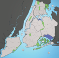
File:Waterways New York City Map Julius Schorzman.png
外觀

預覽大小:616 × 600 像素。 其他解析度:247 × 240 像素 | 493 × 480 像素 | 789 × 768 像素 | 1,052 × 1,024 像素 | 2,104 × 2,048 像素 | 2,652 × 2,582 像素。
原始檔案 (2,652 × 2,582 像素,檔案大小:1.88 MB,MIME 類型:image/png)
檔案歷史
點選日期/時間以檢視該時間的檔案版本。
| 日期/時間 | 縮圖 | 尺寸 | 使用者 | 備註 | |
|---|---|---|---|---|---|
| 目前 | 2013年9月30日 (一) 21:01 |  | 2,652 × 2,582(1.88 MB) | JohnnyMrNinja | Indexed colors, removed unused alpha channel and increased file compression |
| 2005年8月19日 (五) 02:36 |  | 2,652 × 2,582(6.19 MB) | Quasipalm | A map showing the major waterways in New York City. 1) Hudson River 2) East River 3) Long Island Sound 4) Newark Bay 5) Upper New York Bay 6) Lower New York Bay 7) Jamaica Bay 8) Atlantic Ocean Source: I created this image using various maps and images. |
檔案用途
全域檔案使用狀況
以下其他 wiki 使用了這個檔案:
- af.wikipedia.org 的使用狀況
- ar.wikipedia.org 的使用狀況
- ban.wikipedia.org 的使用狀況
- be.wikipedia.org 的使用狀況
- ca.wikipedia.org 的使用狀況
- cs.wikipedia.org 的使用狀況
- da.wikipedia.org 的使用狀況
- de.wikipedia.org 的使用狀況
- en.wikipedia.org 的使用狀況
- eo.wikipedia.org 的使用狀況
- es.wikipedia.org 的使用狀況
- eu.wikipedia.org 的使用狀況
- frr.wikipedia.org 的使用狀況
- fr.wikipedia.org 的使用狀況
- hak.wikipedia.org 的使用狀況
- he.wikipedia.org 的使用狀況
- id.wikipedia.org 的使用狀況
檢視此檔案的更多全域使用狀況。

