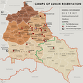
File:General Government camps of Lublin Reservation.png
外觀

預覽大小:605 × 600 像素。 其他解析度:242 × 240 像素 | 484 × 480 像素 | 774 × 768 像素 | 1,033 × 1,024 像素 | 2,299 × 2,280 像素。
原始檔案 (2,299 × 2,280 像素,檔案大小:636 KB,MIME 類型:image/png)
檔案歷史
點選日期/時間以檢視該時間的檔案版本。
| 日期/時間 | 縮圖 | 尺寸 | 使用者 | 備註 | |
|---|---|---|---|---|---|
| 目前 | 2018年5月3日 (四) 17:14 |  | 2,299 × 2,280(636 KB) | Poeticbent | added location of Kulmhof to map & legend |
| 2016年4月17日 (日) 17:10 |  | 2,299 × 2,280(620 KB) | Poeticbent | added missing locations | |
| 2016年4月15日 (五) 04:35 |  | 2,299 × 2,280(609 KB) | Poeticbent | =={{int:filedesc}}== {{Information |description={{en|1=Map of the administrative areas of the General Government}} |date=2012-05-26 |source={{own}} by {{u|XrysD}}, edited by {{u|Poeticbent}} with superimposed camps of Lublin Reservation before and afte... |
檔案用途
全域檔案使用狀況
以下其他 wiki 使用了這個檔案:
- de.wikipedia.org 的使用狀況
- el.wikipedia.org 的使用狀況
- en.wikipedia.org 的使用狀況
- es.wikipedia.org 的使用狀況
- fa.wikipedia.org 的使用狀況
- fr.wikipedia.org 的使用狀況
- it.wikipedia.org 的使用狀況
- no.wikipedia.org 的使用狀況
- pl.wikipedia.org 的使用狀況


