跳至內容

File:Carolingian empire 828.svg

頁面內容不支援其他語言。
這個檔案來自維基共享資源
維基百科,自由的百科全書

原始檔案 (SVG 檔案,表面大小:1,091 × 1,053 像素,檔案大小:348 KB)


摘要

描述
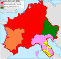
Español: Imperio carolingio en 828 antes de las guerras civiles.
日期
來源

自己的作品

  • [1] Sur l'epoque de la désunion de la Septimanie de Royaume de Aquitaine, & de son érection en Duché, & sur l'acte de partage que fit l'an 817, l'empereur Luis-le-Débonaire de ses Etats entre ses fils.
  • [2] Pepin continued to hold Aquitaine; but the realm sustained various alterations in boundary: only a portion of Septimania, which had hitherto been conjoined with Aquitaine, was retained by him, namely the county of Carcassonne. On the north, the frontier was also somewhat contracted, but the loss was compensated by a dismemberment of Cisjurane Burgundy, three counties -Autun, towering in Roman magnificence: smiling Nevers, and dreary Avalon, where every stone appears stamped with vestiges of once animated nature.
  • [3]: At the Aachen assembly in February 828, Louis the Pious blamed the loss of Lower Pannonia on Balderic of Friuli's "cowardice". Louis the Pious therefore revoked Balderic's honors and divided the match of Friuli into four separate counties: Carantania, Carniola, Istria, and a now greatly reduced Friuli. [...] The province of Carantania at this time passed into the control of the Bavarian king and his eastern prefect. [...] Louis could justify the annexation of Carantania on the basis of the Ordenatio imperii which explicitly included Carantania as part of his Bavarian kingdom. But as the ruler of Italy, Lothar had cotrolled Friuli (including Carantania) since 817. Balderic's downfall in 828 and the resulting Bavarian annexation of Carantania therefore represented Louis's first agressive move against his eldest brother.
  • [4]: Pippin, another son of Lewis, had dominion in Aquitaine and Gascony.
  • [5]: En 817, en Aquisgram, se hizo división entre los hijos de Luis el Piadoso: y Lotario fue asociado al Imperio; Pepino obtuvo la Gascuña y la Aquitania con los territorios de Nevers, Autun, Avallen en la Borgoña.
  • [6]: Pepin continued to hold Aquitaine; but the realm sustained various alterations in boundary : only a portion of Septimania, which had hitherto been conjoined with Aquitaine, was retained by him, namely the county of Carcassonne. On the north, the frontier was also somewhat contracted, but the loss was compensated by a dismemberment of Cisjurane Burgundy, three counties— Autun, towering in Roman magnificence : smiling Nevers, and dreary Avalon, where every stone appears stamped with vestiges of once animated nature.
作者 Trasamundo
其他版本

授權條款

我,本作品的著作權持有者,決定用以下授權條款發佈本作品:
GNU head 已授權您依據自由軟體基金會發行的無固定段落、封面文字和封底文字GNU自由文件授權條款1.2版或任意後續版本,對本檔進行複製、傳播和/或修改。該協議的副本列在GNU自由文件授權條款中。
w:zh:創用CC
姓名標示 相同方式分享
此檔案採用創用CC 姓名標示-相同方式分享 3.0 未在地化版本2.5 通用版2.0 通用版以及1.0 通用版授權條款。
您可以自由:
  • 分享 – 複製、發佈和傳播本作品
  • 重新修改 – 創作演繹作品
惟需遵照下列條件:
  • 姓名標示 – 您必須指名出正確的製作者,和提供授權條款的連結,以及表示是否有對內容上做出變更。您可以用任何合理的方式來行動,但不得以任何方式表明授權條款是對您許可或是由您所使用。
  • 相同方式分享 – 若要根據本素材進行再混合、轉換或創作,則必須以與原作相同或相容的授權來發布您的作品。
您可以選擇您需要的授權條款。

說明

添加單行說明來描述出檔案所代表的內容

在此檔案描寫的項目

描繪內容

檔案來源 Chinese (Taiwan) (已轉換拼寫)

image/svg+xml

6908994735cabc5747629f33d2b509c07bfe85f3

斷定方法:​SHA-1 中文 (已轉換拼寫)

356,703 位元組

1,053 像素

1,091 像素

檔案歷史

點選日期/時間以檢視該時間的檔案版本。

日期/時間縮⁠圖尺寸使用者備⁠註
目前2021年10月28日 (四) 12:09於 2021年10月28日 (四) 12:09 版本的縮圖1,091 × 1,053(348 KB)RowanwindwhistlerLighter colours, fake text added for better rendering in articles (real text is now hidden).
2016年5月4日 (三) 08:34於 2016年5月4日 (三) 08:34 版本的縮圖1,091 × 1,053(251 KB)RowanwindwhistlerSofter colours form http://colorbrewer2.org/
2016年4月22日 (五) 21:38於 2016年4月22日 (五) 21:38 版本的縮圖1,091 × 1,053(251 KB)RowanwindwhistlerClear shapes, some colours from https://en.wikipedia.org/wiki/Wikipedia:WikiProject_Maps/Conventions
2010年3月13日 (六) 18:30於 2010年3月13日 (六) 18:30 版本的縮圖1,091 × 1,053(940 KB)Trasamundolegend
2010年3月13日 (六) 18:26於 2010年3月13日 (六) 18:26 版本的縮圖1,091 × 1,053(940 KB)Trasamundo{{Information |Description={{es|1=Imperio carolingio en 828 antes de las guerras civiles.}} |Source={{own}} |Author=Trasamundo |Date=13 March 2010 |Permission= |other_versions= }} Category:Maps of the Carolingian Empire

下列頁面有用到此檔案:

全域檔案使用狀況

以下其他 wiki 使用了這個檔案:

詮釋資料