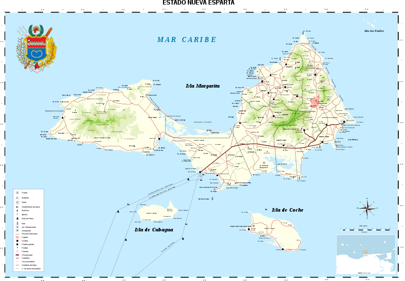
File:Nueva Esparta Mapa Vial.svg
外观

此SVG文件的PNG预览的大小:800 × 555像素。 其他分辨率:320 × 222像素 | 640 × 444像素 | 1,024 × 711像素 | 1,280 × 889像素 | 2,560 × 1,778像素 | 3,612 × 2,508像素。
原始文件 (SVG文件,尺寸为3,612 × 2,508像素,文件大小:1.42 MB)
文件历史
点击某个日期/时间查看对应时刻的文件。
| 日期/时间 | 缩略图 | 大小 | 用户 | 备注 | |
|---|---|---|---|---|---|
| 当前 | 2016年3月11日 (五) 17:59 |  | 3,612 × 2,508(1.42 MB) | Wilfredor | update coat of arms |
| 2015年10月13日 (二) 21:26 |  | 3,612 × 2,508(1.94 MB) | Wilfredor | Adding more information | |
| 2008年11月1日 (六) 19:03 |  | 3,612 × 2,508(1.94 MB) | Wilfredor | {{Information |Description= |Source= |Date= |Author= |Permission= |other_versions= }} |
文件用途
以下3个页面使用本文件:
全域文件用途
以下其他wiki使用此文件:
- ba.wikipedia.org上的用途
- bn.wikipedia.org上的用途
- br.wikipedia.org上的用途
- ca.wikipedia.org上的用途
- crh.wikipedia.org上的用途
- cs.wikipedia.org上的用途
- cv.wikipedia.org上的用途
- da.wikipedia.org上的用途
- de.wikipedia.org上的用途
- de.wikivoyage.org上的用途
- el.wikipedia.org上的用途
- en.wikipedia.org上的用途
- en.wikivoyage.org上的用途
- es.wikipedia.org上的用途
- Wikiproyecto Discusión:Venezuela/1
- Isla de Margarita
- Isla de Coche
- Wikipedia:Candidatos a recursos destacados/Nueva Esparta Mapa Vial.svg
- Wikipedia:Candidatos a recursos destacados/Septiembre-2007
- Wikipedia:Recurso del día/enero de 2008
- Plantilla:RDD/1
- Wikipedia:Imágenes destacadas/Diagramas, dibujos y mapas
- Wikipedia:Recurso del día/agosto de 2008
- Wikipedia:Recurso del día/1 - 100
- Wikipedia:Recurso del día/diciembre de 2009
- Isla de Cubagua
- Wikipedia:Recurso del día/junio de 2011
- Wikipedia:Recurso del día/mayo de 2013
- Wikipedia:Recurso del día/diciembre de 2015
- Wikipedia:Recurso del día/marzo de 2018
- Wikipedia:Recurso del día/julio de 2020
- Wikipedia:Recurso del día/junio de 2023
- es.wikibooks.org上的用途
- fr.wikipedia.org上的用途
- fr.wikivoyage.org上的用途
- hu.wikipedia.org上的用途
- it.wikipedia.org上的用途
- ko.wikipedia.org上的用途
- krc.wikipedia.org上的用途
- lbe.wikipedia.org上的用途
- mg.wikipedia.org上的用途
- mk.wikipedia.org上的用途
- os.wikipedia.org上的用途
- pam.wikipedia.org上的用途
查看此文件的更多全域用途。


