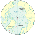
File:Nansen's Planned Drift map.svg
外观

此SVG文件的PNG预览的大小:496 × 490像素。 其他分辨率:243 × 240像素 | 486 × 480像素 | 777 × 768像素 | 1,037 × 1,024像素 | 2,073 × 2,048像素。
原始文件 (SVG文件,尺寸为496 × 490像素,文件大小:1.29 MB)
文件历史
点击某个日期/时间查看对应时刻的文件。
| 日期/时间 | 缩略图 | 大小 | 用户 | 备注 | |
|---|---|---|---|---|---|
| 当前 | 2009年10月12日 (一) 22:36 |  | 496 × 490(1.29 MB) | Lokal Profil | Cleaned up code a bit |
| 2009年10月12日 (一) 22:24 |  | 496 × 490(1.52 MB) | Lokal Profil | Removed FlowPath and added "Greenland" which seemed to be what the intention had been. | |
| 2009年10月12日 (一) 19:44 |  | 496 × 490(1.52 MB) | Niagara | experiment | |
| 2009年10月12日 (一) 19:34 |  | 496 × 490(1.53 MB) | Niagara | fix | |
| 2009年10月12日 (一) 19:30 |  | 496 × 490(1.52 MB) | Niagara | fix | |
| 2009年10月12日 (一) 19:28 |  | 496 × 490(1.48 MB) | Niagara | {{Information |Description = Map of the planned drift to the North Pole and beyond in Nansen's ''Fram'' expedition |Source = Heavily modified version of File:Artide.svg |Date = 2009-10-12 |Author = Dtb |
文件用途
以下2个页面使用本文件:
全域文件用途
以下其他wiki使用此文件:
- be.wikipedia.org上的用途
- ca.wikipedia.org上的用途
- da.wikipedia.org上的用途
- en.wikipedia.org上的用途
- en.wikibooks.org上的用途
- es.wikipedia.org上的用途
- fr.wikipedia.org上的用途
- hy.wikipedia.org上的用途
- it.wikipedia.org上的用途
- ja.wikipedia.org上的用途
- no.wikipedia.org上的用途
- pl.wikipedia.org上的用途
- pt.wikipedia.org上的用途
- ro.wikipedia.org上的用途
- ru.wikipedia.org上的用途
- uk.wikipedia.org上的用途

